


Descrizione di Trekarta - offline maps for outdoor activities
Trekarta is designed for hiking, geocaching, off-roading, cycling, boating and all other outdoor activities. It uses offline maps so you do not need to have internet connection. You can easily import places and tracks from GPX and KML data formats or create places in application and share them to others. It lets you write the track of your journey, even in background, so you will never get lost and be able later see where you've been.
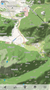
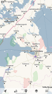
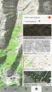
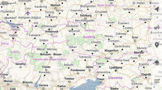
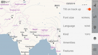
Offline maps
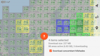
Trekarta uses OpenStreetMap based vector maps that are lightweight, offline and are constantly enhanced by contributors. Maps contain detailed topological data with elevation contours. Some map elements can be filtered out for cleaner look. Trekarta has built-in hillshades support. You can add custom maps in sqlite or mbtiles format to cover your area of interest. Custom maps will be shaded as well. Such maps can be created by yourself with SAS.Planet application from mostly any online source or converted with MapTiler and other applications from other map formats.
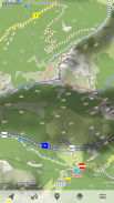
Hiking
Special hiking activity mode emphasises paths and tracks on map. It visualizes path difficulty and visibility and displays hiking routes. It also displays special OSMC symbols that help you identify desired route.
Skiing and skating
Skiing activity mode displays clean winter map with mostly all skiing activities: downhill, nordic, hiking and touring. As a bonus freestyle snow-boarding, skating and sleighing areas are displayed.
Off-road
Unpaved, dirt, winter and ice roads are specially visualized. 4wd only roads have specific marking. Fords are displayed on all roads, even primary.
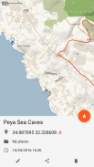
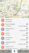
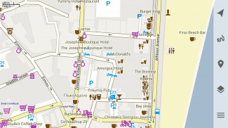
Places
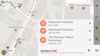
Places can be easily imported from GPX and KML files or can be created within application. You can navigate to places and share them with others.
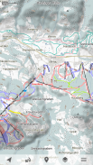
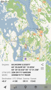
Tracks
Trekarta is designed to record tracks of your journey. Simply press a button when you start and press it once more when you finish. You can quit the application if you do not need to look at the map, the track will be recorded in the background.
Plugins
Trekarta functionality can be extended by plugins. Currently the following plugins are available:
• Location sharing
• Dropbox sync
More info
More information can be found at:
https://andreynovikov.info/tag/trekarta.html
Questions can be asked at:
https://groups.google.com/d/forum/trekarta
Trekarta è progettato per escursioni a piedi, geocaching, fuoristrada, ciclismo, nautica e tutte le altre attività all'aperto. Utilizza mappe offline quindi non è necessario disporre di una connessione a Internet. Puoi facilmente importare luoghi e tracce da formati di dati GPX e KML o creare luoghi nell'applicazione e condividerli con altri. Ti consente di scrivere la traccia del tuo viaggio, anche in background, così non ti perderai mai e potrai in seguito vedere dove sei stato.
Mappe offline
Trekarta utilizza mappe vettoriali basate su OpenStreetMap che sono leggere, offline e costantemente migliorate dai collaboratori. Le mappe contengono dati topologici dettagliati con contorni di elevazione. Alcuni elementi della mappa possono essere filtrati per un aspetto più pulito. Trekarta ha il supporto integrato per le sfumature delle colline. Puoi aggiungere mappe personalizzate in formato sqlite o mbtiles per coprire la tua area di interesse. Anche le mappe personalizzate saranno ombreggiate. Tali mappe possono essere create da soli con l'applicazione SAS.Planet da qualsiasi fonte online o convertite con MapTiler e altre applicazioni da altri formati di mappe.
Escursionismo
La modalità di attività escursionistica speciale enfatizza percorsi e tracce sulla mappa. Visualizza la difficoltà e la visibilità del percorso e mostra i percorsi escursionistici. Visualizza anche simboli OSMC speciali che consentono di identificare il percorso desiderato.
Sciare e pattinare
La modalità attività sciistica mostra una mappa invernale pulita con quasi tutte le attività sciistiche: discesa, nordica, escursionismo e turismo. Come bonus freestyle vengono visualizzate le aree di snowboard, slittino e slittino.
Off-road
Le strade non asfaltate, sterrate, invernali e ghiacciate sono appositamente visualizzate. 4wd solo le strade hanno marcature specifiche. Le corde sono visualizzate su tutte le strade, anche primarie.
Luoghi
I luoghi possono essere facilmente importati da file GPX e KML o possono essere creati all'interno dell'applicazione. Puoi navigare verso luoghi e condividerli con altri.
Tracce
Trekarta è progettato per registrare le tracce del tuo viaggio. Basta premere un pulsante all'avvio e premerlo ancora una volta al termine. Puoi uscire dall'applicazione se non hai bisogno di guardare la mappa, la traccia verrà registrata in background.
Plugin
La funzionalità di Trekarta può essere estesa tramite plugin. Attualmente sono disponibili i seguenti plugin:
• Condivisione della posizione
• Sincronizzazione Dropbox
Ulteriori informazioni
Ulteriori informazioni sono disponibili all'indirizzo:
https://andreynovikov.info/tag/trekarta.html
Le domande possono essere poste a:
https://groups.google.com/d/forum/trekarta
Trekarta - offline maps for outdoor activities - Versione 2023.11
(30-11-2023)
Trekarta - offline maps for outdoor activities - Informazioni APK
Versione APK: 2023.11Pacchetto: mobi.maptrekApp nella stessa categoria
Potrebbe piacerti anche...


